Episodes · 11–12 November 2026
How to follow a storm on the maps
This week a low crosses the Iberian Peninsula from south-west to north-east. Here is how to see it coming in the METEO / Atlas dashboard, step by step, with the same tools we use. And once it has passed, we will check which model got it right.
What the models say (Sunday 8, evening)
- The low: it forms over the Atlantic south-west of Portugal, deepens very fast on Tuesday (the detectors flag it as explosive cyclogenesis) and crosses the peninsula overnight from Wednesday to Thursday at about 984 hPa according to ECMWF. By Friday it is over the Gulf of Genoa.
- Aloft there is a cut-off low (a DANA, in Spanish): a pocket of cold air at 5,500 m that breaks away from the westerly flow.
- Rain: on Wednesday, mainly in the west and centre. On Thursday, in Catalonia: between 10 and 40 mm in Tarragona and Barcelona, depending on the model.
- Wind: on Thursday, gusts of 55 to 85 km/h in the Balearics and along the Valencian coast.
- Thunderstorms: enough energy over the Balearics and the Mediterranean, with the sea still warm.
These are forecasts three and four days ahead: they will change. That is why this page shows you how to look for yourself, with up-to-date data.
Tuesday 10 update
- The track barely changes: the low comes in over Portugal on Wednesday, a little deeper (975 hPa near Lisbon), and by Thursday morning it is over the Bay of Biscay and southern France.
- Rain in Catalonia: it goes down, and the models drift further apart. On Thursday, between 4 and 30 mm in Tarragona depending on the model. Only 4 in 10 scenarios give 10 mm or more in Tarragona (6 in 10 on Monday), and 1 in 3 in Barcelona.
- Wind: it goes up in the Balearics. In Palma, 3 in 4 scenarios give gusts of 70 km/h or more on Thursday. In the Pyrenees and the Gulf of Lion, ECMWF still has gusts of about 140 km/h.
- AROME now reaches Thursday (up to 07:00): until then it keeps the Catalan coast almost dry, with 3 mm in Barcelona.
- The big totals are in the west: from Monday 9 to Sunday 15, the models add up 200 to 330 mm in the Gredos range and the Jerte valley (the UK model, up to 570), and up to 120 in the hills of Huelva and Seville. AEMET has an orange rain warning there. The warmth, on the other hand, stays at 25–27 °C in the Mediterranean cities: no model reaches 28.
- Warnings: AEMET has a yellow warning for rough seas on Thursday from 06:00 to 18:00 along the whole coast of Catalonia and Castellón, and from 06:00 to midnight in the Balearics and Almería: south-westerly wind of 50 to 60 km/h and 3-metre waves. There are no rain warnings for the Mediterranean. On Wednesday there are orange warnings for rain and wind in western Andalusia, Extremadura and Ávila. Meteocat had no warnings yet at 08:30 on Tuesday.
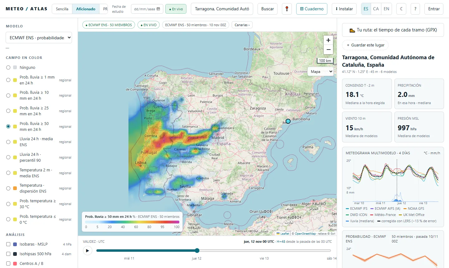
To see it yourself: model «ECMWF ENS · probabilities», «Prob. rain ≥ 50 mm in 24 h» and Thursday 12 at 00 UTC (the 24 hours of Wednesday).
The images in this guide are now from Tuesday's run. On Wednesday we will look again with the full AROME run.
Monday 9 update
- The models are moving closer together: GFS now also takes the low across the peninsula, like ECMWF, and the centre passes a little further north (Ebro valley and Pyrenees).
- Rain: the single-model peaks come down (ECMWF drops from 41 to 19 mm in Tarragona), but the probability goes up. Half of the 50 scenarios now give 10 mm or more on Thursday in Tarragona and Barcelona.
- Wind: it becomes more important. In Palma, more than half of the scenarios give gusts of 70 km/h or more, and ECMWF now has about 70 km/h on the Barcelona and Girona coast. In the Pyrenees and the Empordà, gusts reach 100–120 km/h on Thursday morning.
- Aloft: on Sunday ECMWF cut off a DANA (cut-off low) over the Atlantic; on Monday no model cuts it off. What remains is a trough: the cold air aloft arrives still attached to the westerly flow.
- Warnings: AEMET already has an orange warning for rain in the west (southern Ávila, northern Cáceres and the hills of Huelva and Seville). There were none yet for the Mediterranean: back then they only reached Wednesday.
This is still a forecast two and three days ahead: on Wednesday we will look again with the AROME model.
Step by step
- 1Open the dashboard in the Enthusiast view. Top left, «Simple · Enthusiast · PRO». The Enthusiast view already turns on the isobars, the pressure centres and the detected phenomena.
Open the dashboard in Tarragona - 2Find the low. Move the time bar (at the bottom) to Thursday 12 at 00 UTC. The red circle is the centre of the low and the dashed line is its track. The letters are the phenomena the system detects: D cut-off low, C explosive cyclogenesis, B low, L heavy rain, T thunderstorms, V gusts. Click one to read what triggers it.
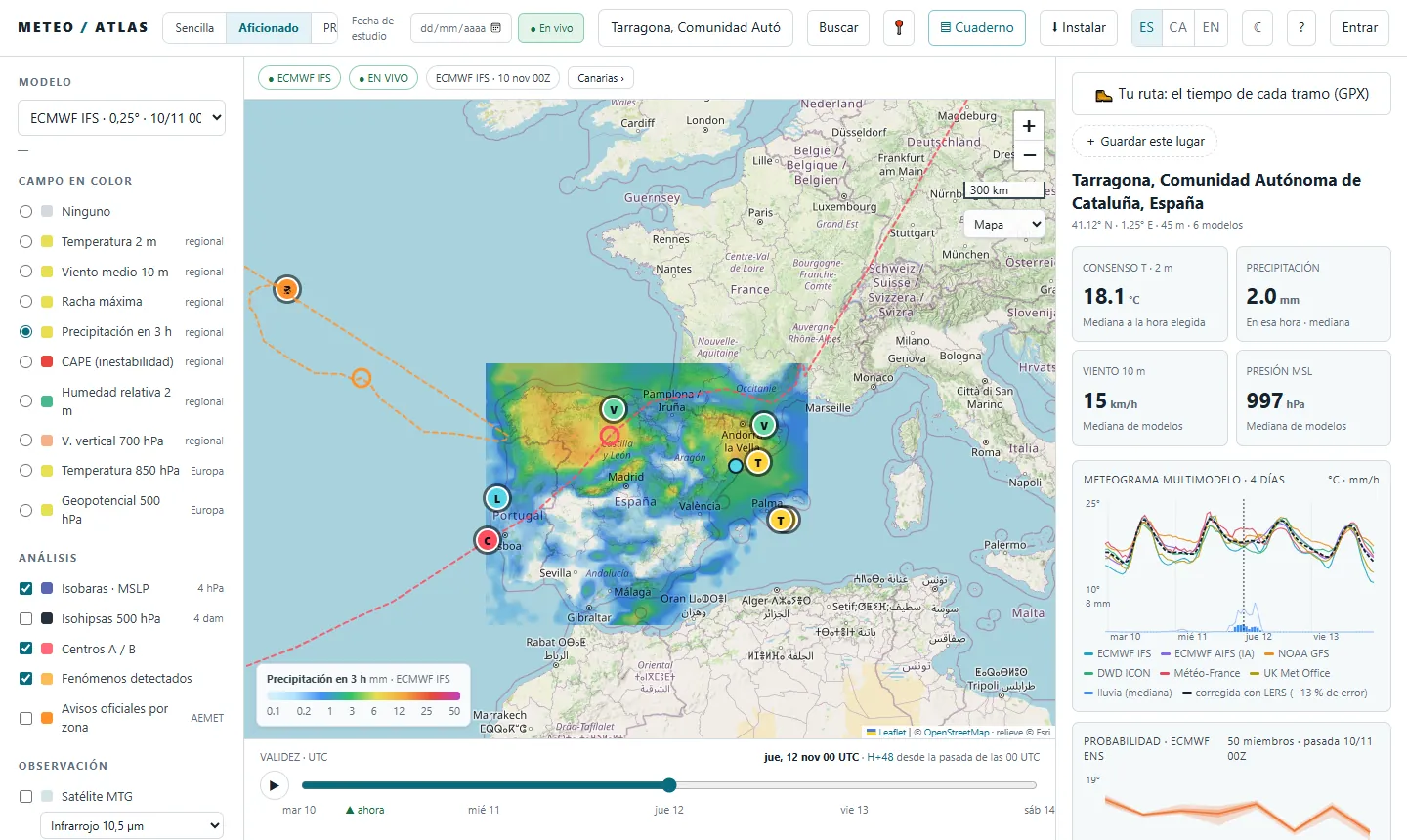
- 3Look up: the cold air. Under «Colour field» choose «Geopotential 500 hPa» and keep the «500 hPa height contours». Set Wednesday 11 at 12 UTC: the blue is the cold air aloft, coming in from the west. On Sunday the system marked it with a purple D (cut-off low) west of Galicia; on Monday it no longer does, because it is still attached to the main flow. If the D comes and goes from one run to the next, the model is unsure. Move the time bar to watch it head towards the peninsula.
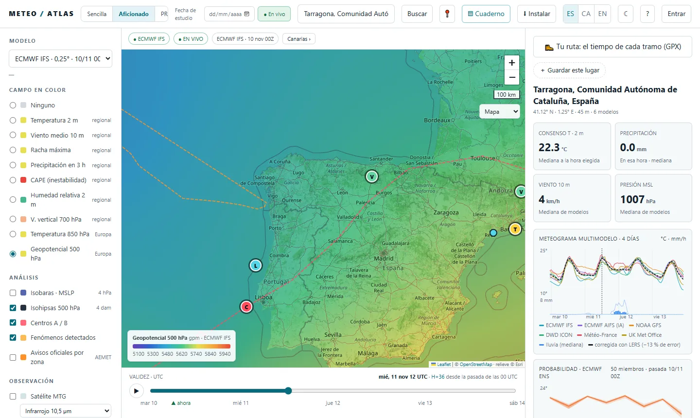
- 4Rain, hour by hour. Choose «Precipitation in 3 h» and press ▶ to animate. On Thursday morning the heaviest rain is over the Pyrenees and the north; little falls on the Catalan coast. Click anywhere on the map to read the value.
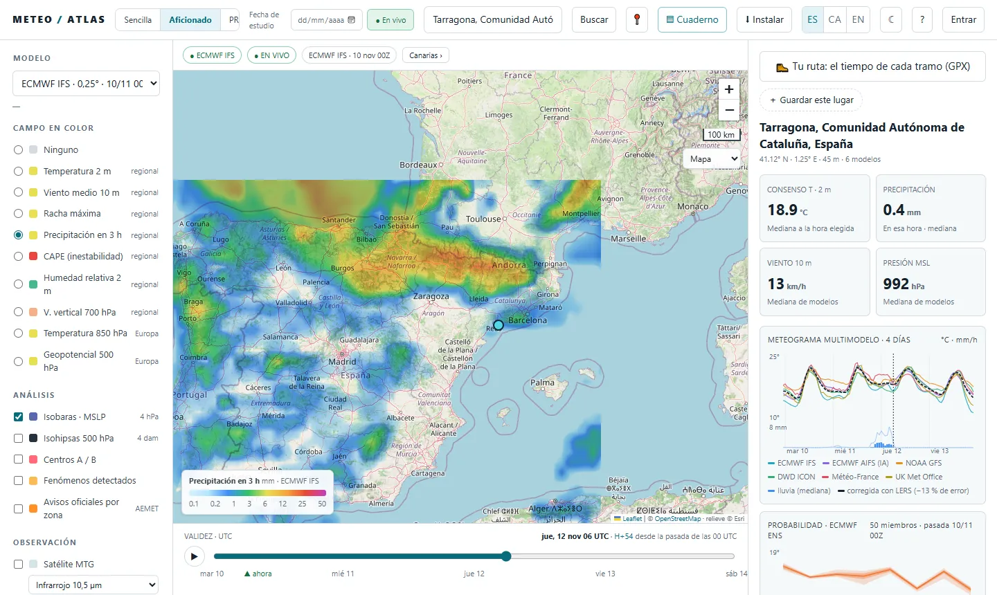
- 5The wind. Choose «Maximum gust». Where the isobars squeeze together, the wind blows harder: on Thursday morning, in the Pyrenees, the Empordà and the Ebro valley; over the sea towards the Balearics, 60 to 70 km/h.
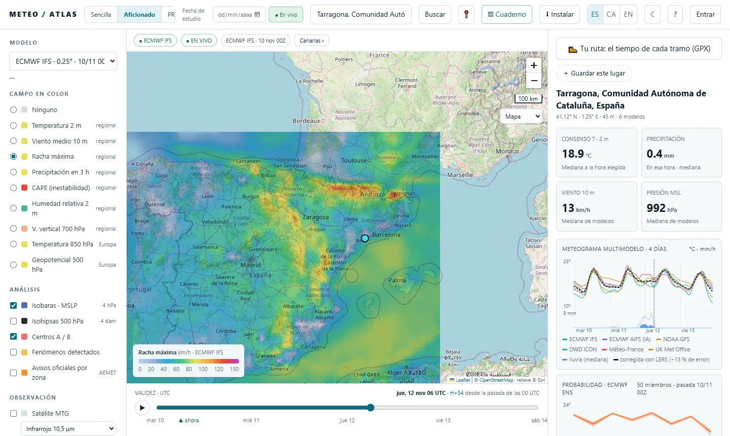
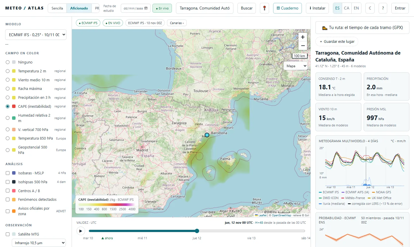
- 6Will there be thunderstorms? «CAPE (instability)» is the energy the air has to rise and build storms. As a rough guide, above 400 J/kg there can be heavy showers and above 1,000, serious thunderstorms. Global models draw storms with a thick brush: the AROME model, at 2.5 km, draws them better. Since Tuesday's 00 UTC run it reaches Thursday at 07:00 (on Monday it stopped on Wednesday morning).
- 7How much to trust it? Switch the model to «ECMWF ENS · probabilities»: 50 scenarios of the same model with small differences at the start. «Prob. rain ≥ 10 mm in 24 h» tells you in how many of them that much rain falls. Red and purple: nearly all; blue: few. If one model shows a lot of rain and the ensemble does not, be wary.
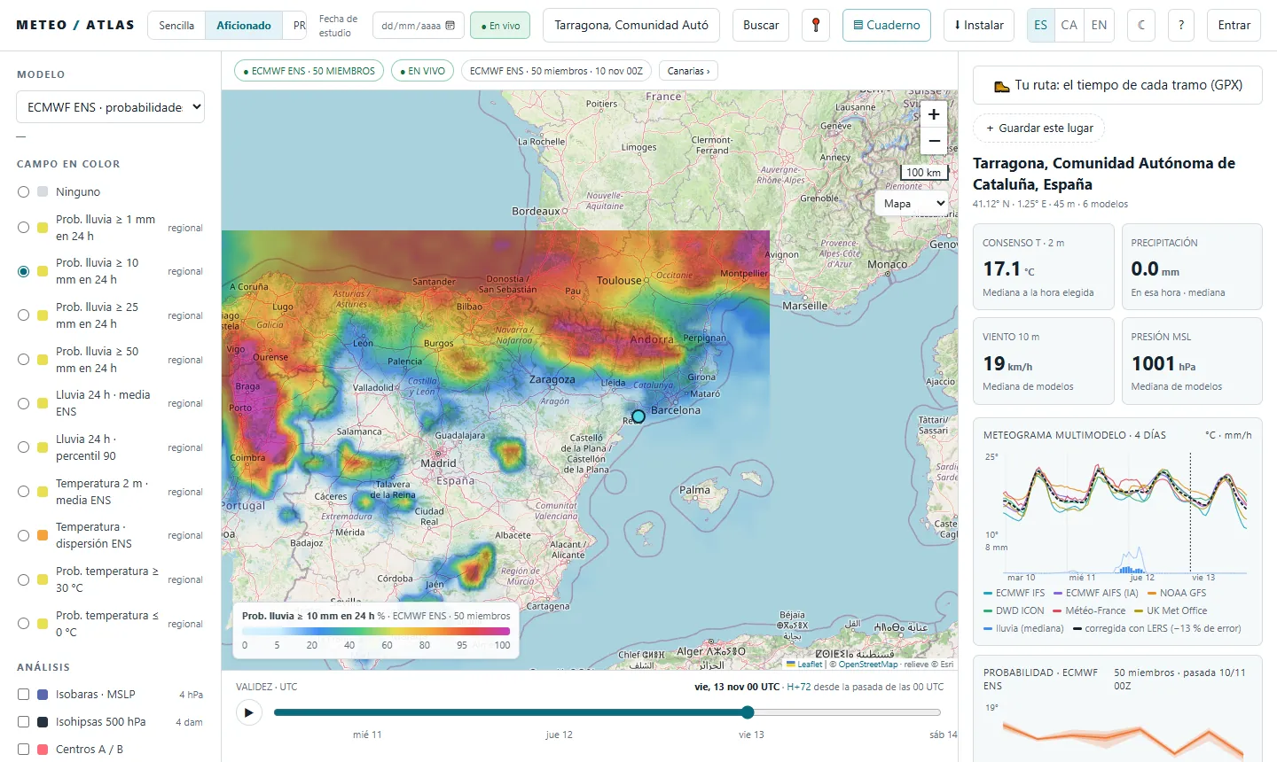
- 8Your town. Search for your town at the top. On the right, the multi-model meteogram puts the six models together: if the lines stay close they agree; if they spread, there is doubt. Below it, the ENS plume with the 10–90 % band.
- 9On the day. Turn on the «Precipitation radar» (with the forecast for the next 90 minutes), «Lightning · MTG-LI», «MTG satellite» and AEMET's «Official warnings by zone». «What people report» shows what you send us from the street. Send what you see: it helps check the radar.
And afterwards, who got it right?
We have saved what each model said on Sunday 8. Once the episode is over we will compare it with what the Meteocat and AEMET stations measure and publish the results here, in Why it went wrong and in the model league. You will also be able to replay it all in the dashboard with «Study date».
Atlas does not replace official warnings. To make decisions, follow AEMET, Meteocat and Civil Protection.